-
Author
Bhaveeka Madagammana -
Date
29 Oct 2026
Essay
Tāmaki Makaurau: A Constellation of Kai Māori Spaces
A popular derivation of Tāmaki Makaurau, the name for Auckland in te reo Māori, describes a land ‘desired by many’ or the ‘Tāmaki desired by a hundred lovers’1 though there are others which are less known.2 Examining Tāmaki from a perspective which prioritises its lineages of kai Māori (Māori food) spaces suggests a complex, yet resoundingly clear picture of the city. The isthmus has been continually inhabited by interrelated groups who utilised and transformed the entirety of the region, through kai design modifications.
Tāmaki’s islands were likely the first places to be substantially inhabited by arriving Polynesians. These ocean voyagers were experts at creating island kai (food) systems and quickly established coastal kāinga (settlements) from which they could easily navigate across the harbours to identified and shared mahinga mātaitai (customary seafood gathering site) spaces to harvest a range of shellfish, seabirds, fish and sharks. Evidence of the earliest inhabitation from the 14th centuries has been found on well-known islands such as Motutapu3 and Aotea (Great Barrier Island)4, but also on obscure ones such as Ōtata in the Noises north of Rakino.5 Some of these islands are volcanic maunga (mountains) as such as Motukorea (Browns Island) and Puketutu and are relatively small compared to larger ones on the mainland such as Maungakiekie (One Tree Hill) and Maungawhau (Mt Eden).
Volcanic maunga are Tāmaki’s most recognisable remnants of Māori inhabitation. Typically terraced across multiple tiers from summit to base, they were sprawling kāinga from which radiated outwards organised māra kai (food gardens) which took advantage of the surrounding rich volcanic soil.6 Māra kai in these regions were delineated by walls and mounds constructed by Māori who utilised scattered volcanic matter into rock features that could heat the soil and shelter imported Polynesian crop varieties.7 The breadth, scale and longevity of Māori inhabitation across these islands from the 14th century onwards demonstrates the creation of a designed multi-island kai network that endured for centuries. This relational pattern of cultivation shaped all of Tāmaki’s islands, effectively maximising production and diversity of nutritious and sustaining kai for Māori communities.
These multi-Island kai systems were closely related to the dense forest bastions of the Te Wai Nui a Tiriwa (Waitākere) and Te Ngāherehere o Kohokuhuni (Hūnua) to the west and southeast respectively of the central isthmus. Both are not only key areas for kāinga and mahinga kai (food-gathering place) but also protected sanctuaries for animals, building materials and spiritual spaces for the development and exchange of mātauranga Māori (Māori knowledge) and rongoā Māori (Māori medicine).8 Each forest acts as a distinct, counterbalancing force for primarily forest kai in similar ways as Te Mānukanuka o Hoturoa (Manukau Harbour) and Waitematā Harbour are for kai moana (seafood).
Between the islands, forests and volcanic maunga were innumerable rivers, wetlands, marshes, swamps, and lakes. Waterways suffused the entirety of the landscape and created critical portage routes, which allowed multiple ways to cut across Aotearoa’s eastern and western coasts, as well as from the Waikato River to the Kaipara Harbour. Intertidal and water-saturated spaces were significant habitats for harvestable plant and animal species and were integrated within seasonal patterns that drew upon developed mahinga kai (food-gathering place) and mahinga mātaitai (customary seafood gathering sites).
Auckland Council’s map, ‘Māori Identity and Wellbeing – Tangata Whenua,’ records Māori archaeological sites within the supercity boundaries and demonstrates the vastness of constructed kai Māori spaces since the beginning of their inhabitation.9 It likely captures just a small fraction of Māori modifications as huge tracts of land have been irrevocably changed through dispossession and environmental degradation since colonial settlers arrived. The map reinforces a significant point, from a regional perspective which amalgamates forests, harbours, islands and volcanoes together, Tāmaki Makaurau is a giant constellation of designed kai Māori interventions woven into a sophisticated kai system by interrelated groups who fully realised its fertile potential through continual intergenerational occupation.
Tāmaki's current food system faces risk and collapse due to the fragmentation and subdivision of land occurring across the city which will likely drive up food prices and adversely impact food security.10 Urban development irreversibly renders land unproductive and increases future food costs.11 21st century planning often relegates food spaces, typically intensive horticulture and agriculture to the city’s periphery established through zoning.12 However, in privileging spatial dimensions of kai Māori in Tāmaki, alternative ways of conceptualising kai within our city which uplifts our well-being emerges. For centuries Māori communities lived within kai saturated environments in a seasonal balance that incorporated the immanence of Tāmaki in their cycles of habitation. Furthermore, by expanding our understanding of design to encompass kai related modifications such as māra, today’s iteration of the city is just a temporary configuration within a lineage of kai spaces that characterised the region for centuries.
—
Bhaveeka Madagammana is a PhD candidate and former educator at the University of Auckland’s Te Pare School of Architecture and Planning, and a part of MĀPIHI Māori and Pacific Housing Research Centre. His research centres on the exploration of Indigenous architectural food spaces. He currently works at the Waitangi Tribunal Unit as a Research Analyst.
—
1 R. C. J. Stone, From Tāmaki-Makau-Rau to Auckland, (Auckland: Auckland University Press, 2002), 7–8, ProQuest, https://ebookcentral.proquest.com/lib/auckland/detail.action?docID=156393.
2 Agnes Sullivan, Maori Gardening in Tāmaki before 1840, vol 1(Traditional, Ethnographic and Other Historic Documentary Sources, Auckland, Auckland City Council, Unpublished Manuscript) 24–25.
3 Janet Davidson, “THE PREHISTORY OF MOTUTAPU ISLAND, NEW ZEALAND FIVE CENTURIES OF POLYNESIAN OCCUPATION IN A CHANGING LANDSCAPE”, Journal of the Polynesian Society 87, No. 4 (1978), 332.
4 Susan Bulmer, The Archaeological Sites of Aotea (Great Barrier Island) and their Management, (Auckland: New Zealand Historic Places Trust, 1980), 2.
5 Matthew Campbell, Richard Walter, Armagan Sabetian, Louise Furey, Emma Ash, Andrew McAlister, Jingjing Zhang, and Caitlin Haylock, “Fish from the Ōtata Midden: Change and Continuity in Pre-European Māori Fisheries”, Frontiers in Environmental Archaeology 4 (July 2025), https://doi.org/10.3389/fearc.2025.1565503.
6 Kevin Jones, The Penguin Field Guide to New Zealand Archaeology, (Auckland: Penguin Books, 2007), 92.
7 Louise Furey, Mā̄ori Gardening: An Archaeological Perspective, (Wellington: New Zealand Department of Conservation, 2006).
8 See Graeme Murdoch, A Brief History of the Human Occupation of Muriwai Regional Park and its Environs, (Auckland: Auckland City Council, 1994), and Graeme Murdoch, “Part One: The Land”, Waitakere Ranges: Ranges of Inspiration: Nature, History, Culture, ed. Bruce Harvey and Trixie Harvey, (Auckland: Waitakere Ranges Protection Society, 2006).
9 Auckland Council, “Māori Identity and Wellbeing – Tangata Whenua”, Accessed 30 August 2026, https://mapspublic.aklc.govt.nz/portal/apps/webappviewer/index.html?id=2b345ca0411b4c5dac61f465be53ebd5.
10 Deloitte and Horticulture New Zealand, New Zealand’s food story: The Pukekohe Hub, (Wellington: Deloitte, 2018), 21.
11 Ministry for the Environment and Stats NZ (2024), New Zealand’s Environmental Reporting Series: Our land 2024, (Ministry for the Environment and Stats NZ, 2024), 14, 26, 34. Available from environment.govt.nz and stats.govt.nz.
12 Auckland Council, “Auckland Unitary Plan July 2026 planning maps”, Accessed 11 October 2026, https://unitaryplanmaps.aucklandcouncil.govt.nz/upviewer/.
—
Images:
Fig. 1 A vast majority of the volcanic flats surrounding Maungakiekie (One Tree Hill) stretching to Waiatarua (Ellerslie) was home to Ngā Māra ā Tahuri in the 18th century, possibly the largest singular organised Māori horticultural area on the isthmus. Maungakiekie from Ladies Miles Rd Remuera, 2021, photo by Bhaveeka Madagammana.
Fig. 2 The Noises, cluster of small islands, Hauraki Gulf, Auckland, 1954, photo by Whites Aviation, Alexander Turnbull Library WA-34631-F.
Fig. 3 The Mangitangi Stream in early 20th century. Irrevocably altered due to the construction of the Mangitangi Dam in 1972–77. Mangatangi Stream, Hunua Ranges, Auckland Tramping Club, 1920s–30s, Auckland Libraries Heritage Collections 282-0274.
Fig. 4 Lake Waiatarua (Lake St John) with Maungarei (Mt Wellington) and present day Stonefields in the background as seen from present day Meadowbank. The lake was drained in 1928 and is now Waiatarua Reserve, a wetland. Lake St John and Mount Wellington, 1916, photo by Henry Winkelmann, Auckland Libraries Heritage Collections 1-W1575.
Fig. 5 View over Hobson's Gully now Newmarket Park looking towards Ōhinerau (Mt Hobson), Hobsons Gully, Auckland, 1866, photo by Rev. John Kinder, Hocken Collections, University of Otago Library P1922-001-047.
Fig. 5 The Waitākere Falls in 1898, destroyed by the construction of the Waitākere Dam in 1910, Lower Waitākere Falls, Waitākere Ranges, c. 1898, photo by Ernest Charles Binns, Auckland Libraries Heritage Collections 80-BIN011.
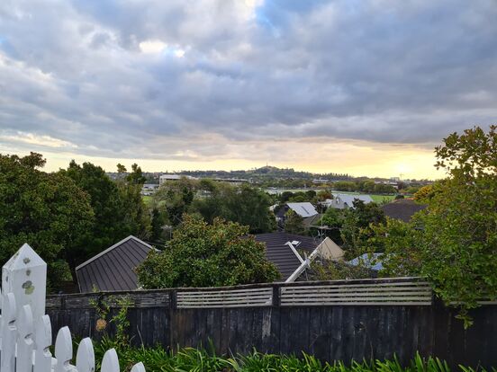
Fig. 1
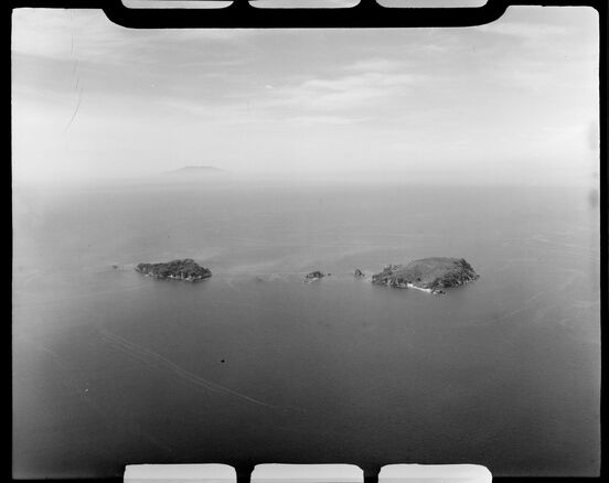
Fig. 2
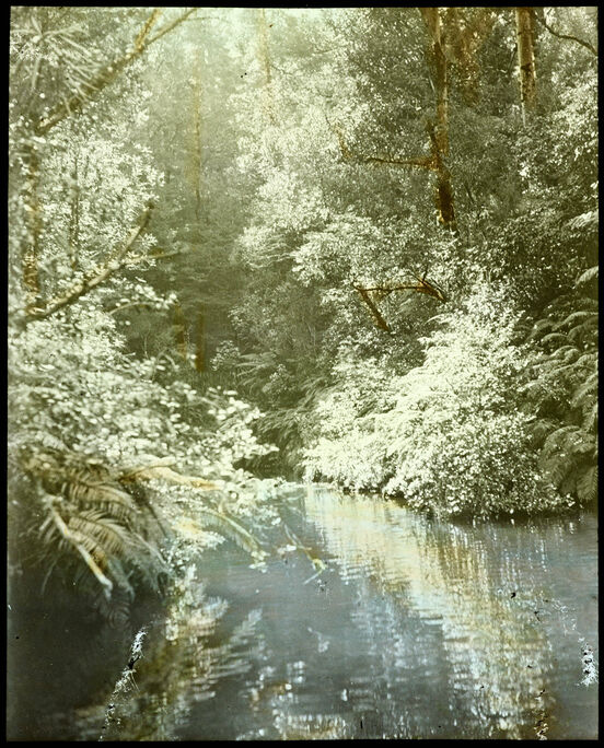
Fig. 3
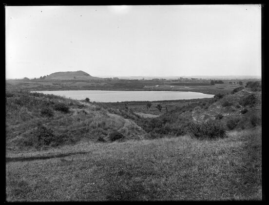
Fig. 4
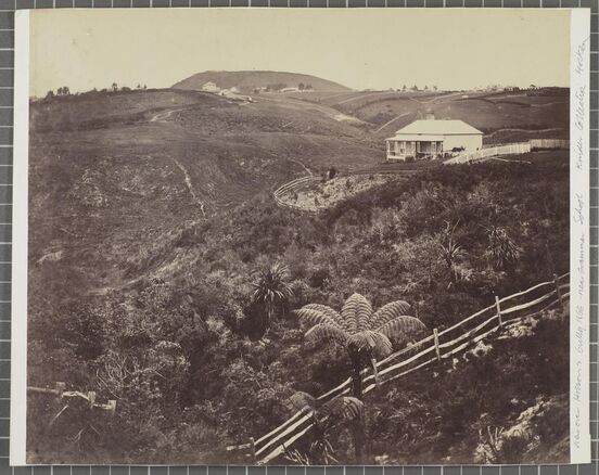
Fig. 5
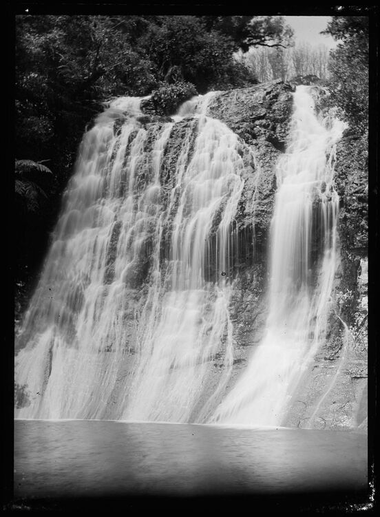
Fig. 6