-
Author
Kim Paton -
Date
14 Oct 2026
Essay
Edge City
It started with a park beside a big-box shopping centre in Westgate, just off State Highway 16. For a couple of years in the late 2010s I found myself there most weekends – it was a stop-off in a Saturday-morning sports routine that took us as far as you can go into the bowels of Albany. A 45-minute drive, for an activity of the same duration. If I lengthened the whole trip by stopping for something to eat on the way home, I reasoned, it would help justify the eyewatering hassle of it all.
The park, Kopupaka Reserve, was designed by Isthmus Group. Its main feature is a series of long, arcing retaining walls, made in a latticed timber formation. Forming part of a wider stormwater system, the reserve appears from a distance woven and beautiful – a visual relief amid a wash of concrete greys and super-sized bed stores. It is heavily planted and dotted with picnic tables and seating throughout. But from what I recall of those early visits, it was always empty: in all the Saturday mornings I spent there waiting for food across the road, I can’t remember anyone else using the space.
Over the years since the morning sports finished, I have developed a mild obsession with the reserve and the new suburb emerging around it. Originally called Massey North, Westgate was planned in the early 2000s by Waitakere City Council, which envisioned it as a self-contained town. It came to be known as Westgate, named after the shopping centre built there in 1998, and over the past 10 years of development, a vast retail complex north of the busy Fred Taylor Drive has divided the existing Westgate Shopping Centre from its newer NorthWest counterpart, which includes a town square and generous library.
Big-box retail developments have closed in around Kopupaka Reserve, creating strange retail duplications with the original shopping centre. You can find double-ups of Woolworths, McDonald’s and big-chain chemists all within walking distance of each other.
Since it opened in 2022, the much-anticipated Costco injected a surge of fevered consumer interest in the area that hasn’t waned. You can find the Westgate offramp clogged at seemingly random times of day; the main street that borders Kopupaka funnels queues of cars towards it. In 2024 a drive-thru strip opened behind the Costco petrol station. A single long warehouse contains four fast-food giants – Taco Bell, Carl’s Jr., Starbucks and KFC – in an interconnected row. Theoretically, you can drive in a continuous snake through each restaurant, with the drive-thrus fully integrated inside the building.
Across the road from the petrol station, opposite the new Tesla showroom, a section of the reserve continues. It fills a void between the back end of Costco and the point when Westgate fades into nothing – becoming a landscape of gorse and gravel roads, waiting for whatever development comes next in the gap beside the motorway. Seen in this context, the park with its visual greenery and pristine benches that are hardly used seems to act more like an illuminated sign, something to look at but never to stop for. It performs an idea of pedestrian-friendly communal space for a public who will only ever see it through the window of a moving car.
I have lived in West Auckland for a decade now, most recently very close to Westgate, in a suburb undergoing its own rapid change with the onslaught of cheap terraced infill housing. I work close to the central city in the leafy suburb of Grey Lynn. During the 10 years of this commute I’ve come to see two entirely conflicting ideas about the current shape and possible future of Auckland’s urban form. Two lines of growth, running in completely opposite directions.
The first runs towards the inner city. It offers an image of Auckland as high density and high functioning, unshackled from sprawling traffic woes and its long love affair with the suburbs. A city of connection and culture that oscillates around its centre. The counter-possibility pushes the city outward, growing at its margins. It is the dream of suburban life that has never died, an idea that balances the necessity of neighbours with bucolic ideals that derive from the countryside.
—
The pendulum swing between town and country shaped how Europeans settled this land. For decades the suburb was baked into our cultural identity as the ideal condition for making home. But its introduction is relatively new, emerging in the early 1900s as a remedy to the increasingly populated towns, which had seen, for the first time, more people living in urban areas than rurally. In his book The Big Smoke, historian Ben Schrader draws on earlier scholarship to paint a tumultuous picture of a New Zealand in transition at the beginning of the 20th century: widespread anti-urban sentiment accused the city of being squalid and unsafe, while in contrast farming was thought to provide economic security entrenched in moral values. Rural dwellers were cast as “superior to townspeople because they worked the land and generated the colony’s wealth”.
The suburb offered a middle realm, a compromise at the outskirts. From this mid-placed locale the city could still be accessed by workers, without them being subject to its culture. “The single unit dwelling on its own suburban section”, Schrader writes, “confirmed the family as a ‘self-contained soil-rooted institution’. Suburbia was a compromise on the smallholding ideal, but if there was a room for a garden and a few chickens it was the next best thing.”
The introduction of electric tram lines in 1902 saw the first Auckland suburbs develop close to its centre. The classic villa positioned proud to the street, was the archetypal house form and can still be found in suburbs like Ponsonby, Grey Lynn and Mt Eden today. But it was the First Labour Government’s rental housing scheme, initiated in the mid-1930s, that saw new suburbs built at scale and full force. These first state housing developments were designed to be garden suburbs, modelled on their counterparts in Britain. Inspired by the mass-produced housing pioneered by New Zealand Railways for their workers, houses were positioned along curving, tree-lined streets, each set within its own garden. Over time the building form simplified, losing the verandah and large windows of the villa, with the front door often positioned away from the street. Its spatial effect was fortressed – less community focused, more nuclear family – drawing the focus of the household inward.
In the 1983 television documentary, The City and the Suburb, produced by Bill Saunders and presented by Hamish Keith, grainy black and white footage from the early 1950s capture the Freemans Bay slums as an inner-city neighbourhood vilified for its residents and left to disrepair. Middle-class families had been leaving the city and settling in the newly minted edges of Auckland, incentivised by house-buying schemes and the region’s modernising motorways. By the early 1980s, 30 years later, fluctuating trends were seeing those families make a return.
A mother from one of these incoming households is interviewed. She describes the appeal of the mix of ethnic groups that attend the local school, foreshadowing the looming gentrification of the area that she herself is contributing to. The predominately Pākehā house-buying families moving back towards the city were attracted by the idea of a more urbane life; but in the process, and over several decades, thousands of affordable rental properties in the surrounding suburbs were eradicated, and the large Māori and Pacific communities who called them home were priced and crowded out.
Today these suburbs represent a lifestyle unobtainable to many. Well connected to amenities, in walking distance of good schools and a short bus ride to the central city, Freemans Bay, Grey Lynn and Ponsonby all contain a breathtaking mix of services and opportunity. Parks, beaches, bars and retail are located within minutes of each other, and are easily accessible by public transport. These one-villa-per-section properties, part of the increasingly fortified inner-suburb ring of affluence, are coveted for the way they offer the best of both worlds: they’re as close as you can get to the city without living in it. It’s from here that the most vocal opposition to the architectural monoculture of the outer suburbs is blasted. Now character protected, these suburbs are disproportionately shielded from development that would encourage greater density and a diversity of residents.
The City and the Suburb ends with a shot of His Majesty’s Arcade on Queen St. It is evening, and people spill out on to the street. The suggestion is that the crowds – educated people going to the theatre or out for dinner – are heading home after a night out in the city. Auckland is a city that dies at night because no one lives there, Keith tells the viewer. Once all the people have got back into their cars and gone home to the supposed tranquillity of the suburbs, the city becomes a dark and dangerous empty shell.
A lot has changed since Keith was lamenting that the city had been maligned and neglected, starved of the development it needed to truly thrive. In the early 1980s the inner-city proper had a only token population, but since then, an intensity of new development and transport infrastructure has turned towards the centre, bringing apartment dwellers with it and finally diversifying Auckland’s typology of housing. But the provocations he brought forth are still relevant to the housing debates we have today. Keith suggested the suburbs, symbolically representing the values of hard work, health, family – the virtues of living close to the soil – were in 1983 no longer suitable for the complexities of modern life. Four decades later, however, their pull for many is as strong as ever.
—
The suburbs are easy to deride as soulless and unlovely. They have been scorned by architects, artists and writers for as long as they have been around. In 1947, Austrian–New Zealand architect Ernst Plischke wrote on the “bleakness and monotony of so many new suburbs” with their “seeming lack of activity and any point of focus”. His complaint was published in Design and Living, a book commissioned by the Department of Internal Affairs to educate New Zealanders in the modernist principles of good postwar design. Plischke championed standards for street, suburb and town design that still hold true today – communities are best served when their environments encourage many different uses, designed for an array of activities (and people). The ideal is one of intermingling rather than arranged and divided zones.
Writing in 1971 under the pseudonym Ivor de Wolfe, the verbose English architectural editor Hubert de Cronin Hastings argued that the industrialised city which emerged in the postwar period had failed in its race to serve the incoming population boom. He cites the insurmountable task of repairing the reputation of the modern city, considered unsafe and unreliable, as one impetus for the amalgamation of town and country that followed.
Certainly, the new suburbs and small towns that emerged on the periphery of cities lacked the necessary infrastructure of self-sufficiency. Instead of the old town square or more recent community centre, Hastings noted, the binding feature at the heart of these suburbs was the prefab concrete form – large-scale shopping malls and super-stores. These remote objects, surrounded by a wasteland of car-focused development, not only lacked the density and action of a city centre but also destroyed the surrounding landscape.
Fifty years on, Hasting’s raging descriptions of the new British suburbs can apply equally to developments in Auckland. Westgate’s beating heart won’t be found in its town square or at Kopupaka Reserve; instead, the bustle of crowds and human connection happen inside Costco, a modern-day public meeting place that isn’t public at all. This leads to problems of access and ownership, as private businesses on private land can revoke permission at any time to those who use them.
One afternoon in September on the streets outside the wholesale giant, shoppers could be spotted vying for over-sized trolleys left abandoned on the road. Inside, hundreds of people streamed down the escalators from the internal carpark and queued to swipe their membership cards. Costco provides an array of choices that amount to a High Street all inside: tyre changes, hearing tests, groceries and clothing, and the famous hot-dog-and-drink combo for $1.99. For all the easy criticism Americanised bulk-shopping can inspire, its no-frills affordability is serving an essential community need.
Beyond Costco and the reserve, there are blocks of empty land that run up towards the west. Across the road, fingers of new housing developments begin – then terminate shortly afterwards in literal countryside. Cows graze in open fields. Beside them, narrow streets already painted out with no-parking lines host various single-dwelling houses in different stages of construction. Lacking any comprehensive master planning and oversight – such as that afforded to Hobsonsville Point close by – Westgate has been mired in a two-decades-long battle between Auckland Council and private developers.
It is hard to locate the original ‘garden suburb’ conceit in the new housing at Westgate. There are no large sections or large homes, and beyond the neighbouring farms green space is nowhere to be seen. Instead, the repetition of crowded, boxy single houses reads as a poorly rendered collage of the traditional street form; the result is new allotments of tightly bound roads that unfurl beside existing countryside. Streetside planting is non-existent or yet to come. And the webs of dead-end streets are both disconnected from each other and severed from the town centre by a major arterial route.
Flat Bush, by contrast – at the opposite, southeast corner of Auckland’s fringes – is almost 30 years old and was planned with much forethought by Manukau City Council. A source of pride for Manukau’s long-time mayor, Barry Curtis, the new town offers a vision that Westgate doesn’t dare contemplate. It is home to a population of 55,000 people, housing them on a vast, hard-to-comprehend scale. Now sitting close to the suburb’s centre, Barry Curtis Park was the unassailable heart of the original masterplan: the largest urban park built in New Zealand in the past 100 years, it is more expansive than Auckland Domain.
Back in 2008, Bruce Harland, the council’s manager of design and development at Flat Bush, described plans for an 18-hectare town centre adjacent to the park. It was to be based around a traditional “mainstreet concept”, and contain “a diverse range of activities including residential, retail, office, community, cultural and recreational activities, all within a compact pedestrian-friendly environment”. Harland’s promised main streets never materialised, however – instead there is a Pak’nSave and a blink-and-you-miss-it mall, optimistically branded the Ormiston Town Centre. Unlike Westgate, medium-density housing does surround the retail area, but no one is walking to buy their groceries. Flat Bush remains disconnected from any rapid transport; its car dependence is all-embracing, evident in its suburban streets choked with parked cars that overflow from surrounding properties.
Flat Bush is built around multiple green fingers that extend from the surrounding hills following natural waterways. From an aerial view you can see them, some running all the way through to the park. But on the ground the suburb appears as an uninterrupted plain of pitched roofs – the relentless dominance of housing is overwhelming. Since the initial plans in the 1990s, new master plans to improve the area have come and gone. Parcels of land sold off by council have created a patchwork of unconnected development, leaving blank spaces in otherwise dense streets of housing, and there are entire Reddit threads (“Rant, hate the dumping of crap”) devoted to recording and complaining about rubbish left on the empty sites.
Greenfield development is the modern-day frontier. Building on pristine land is tempting, offering a blank slate to start again. If you travel south from Flat Bush on State Highway 1, between the turn-off to Drury and Pukekohe township you’ll find Paerātā Rise. Developed by Wesley College Trust, a subsidiary of the Methodist Church, which owns the land, Paerātā is a new suburb in the middle of nowhere. It is bordered at every edge by farmland, and stands on what was once a dairy farm; the land to the south, towards Pukekohe, has some of the most arable soil in New Zealand.
With the new Paerātā train station on the Eastern Line scheduled to open in 2026, the new development will have a viable public transport route to the inner city. Where Westgate is an unplanned suburb, belatedly developing around a large and ad hoc retail hub, Paerātā Rise is its opposite: despite the perversity of its location it feels methodically planned. When you turn off the motorway and into the subdivision, the first thing that appears visible on the rise is a new, well-appointed school, surrounded gently by housing. Other than a busy café there are no shops at all. Streets are well-connected, set into dense greenspace, with cut-through paths and varied public spaces. Like Kopupaka Reserve, Paerātā sends a signal to the public, this time communicating a care for its citizens through its design.
For many of us used to older and more slowly accreted suburbs, Paerātā Rise will have an unnervingly cookie-cutter feel. You can peruse a street of showrooms on Te Rātā Boulevard – town house, modern house, country house, mini mansion – each one a simulacrum of a real home you could buy. The overall success or failure of the suburb as a built environment and a new community remains to be seen; Flat Bush and Westgate show us that early vision and ideals are prone to weakening over time. Questions remain: will the original design principles be maintained as development expands around the new centre? And what measures will be taken to preserve the wider area as a food basket for the region?
—
It would be reckless to overlook the aspects of the suburbs that for so many hold appeal. For 100 years we’ve focused settlement plans on the promise of an urban life in proximity to nature, all made possible by the car. Trying to unpick these prior decisions is an insurmountable task. We are all attracted to places and ways of living with which we identify. If built environments are designed to keep us apart – in cars or siloed in single-dwelling houses – it becomes increasingly difficult to comprehend what other people value most when it comes to making a home. A critical test for the success of a city or a suburb is: who does it invite in and who does it deter?
On one of my recent visits to Westgate I was walking at dusk down from the northern end of Fred Taylor Drive towards my car parked two kilometres away at the edge of the NorthWest mall. There are no side streets in the road design that would make for a quicker route, and I cut through the sprawling carpark that serves Mitre 10 towards an accessway behind the Costco petrol station. It was still light outside and the carpark was getting close to empty. Out of nowhere an alarm blared and a police siren sounded, followed by the sound of a man’s voice. “I am watching you on live CCTV,” he said. “I am sending the footage to the New Zealand Police… leave the premises now.” But it was not an actual human – an automated security tower, it turned out, was unimpressed with my chosen path.
A fortnight later, on a Saturday afternoon, I was halfway up Flat Bush School Road and crossed the road to get a better look at the Tuscany Estate development, expanding its construction down from the ridgeline of the hills. Standing on the public footpath I heard the same pre-recorded man, warning me I’m not wanted here and I had better move along.
—
Kim Paton is the director of Objectspace. Her interest is in interdisciplinary exhibition making across the fields of craft, design, architecture and contemporary art. Paton has curated and written extensively on object-based art forms, including for the Warwick Freeman monograph Hook Hand Heart Star (arnoldsche Art Publishers, 2025). She is co-editor of the publication The Chair: A story of design and making in Aotearoa (Objectspace, 2024) and co-authored the book Contemporary Jewellery in Context (arnoldsche Art Publishers, 2017). In 2024 she was awarded the Garvey Cup by Te Kāhui Whaihanga New Zealand Institute of Architects.
—
This piece has been re-published to accompany In the image of the city, 11 Sep–15 Nov 2026 at Objectspace in Tāmaki Makaurau Auckland.
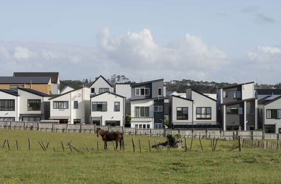
Westgate: An idea of a good life wrapped up in qualities that can be traced back to the countryside. All photographs by David Straight, 2026.
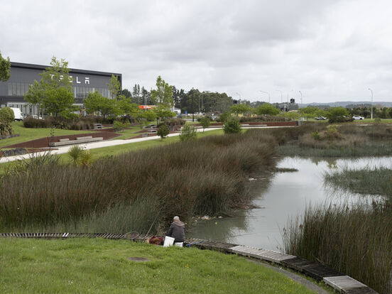
Kopupaka Reserve, Westgate: Visual relief amidst a wash of concrete greys and supersized bed stores.
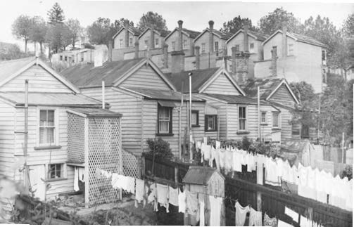
Rear view of houses in Whitson Terrace, and houses in Howe St, Freemans Bay, 1953. Photo: Auckland City Council.
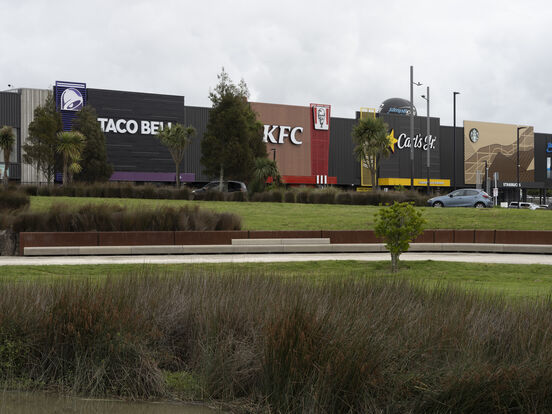
Westgate: You can theoretically drive in a continuous snake through each restaurant: Taco Bell, KFC, Carl’s Jr. and Starbucks.
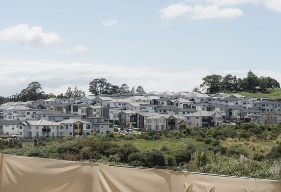
Parcels of land sold off by Council continue to create a patchwork of unconnected development leaving blank spaces in otherwise dense streets of housing, Flat Bush.
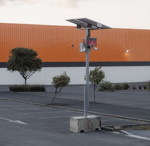
“I am watching you on live CCTV: leave the premises now.”
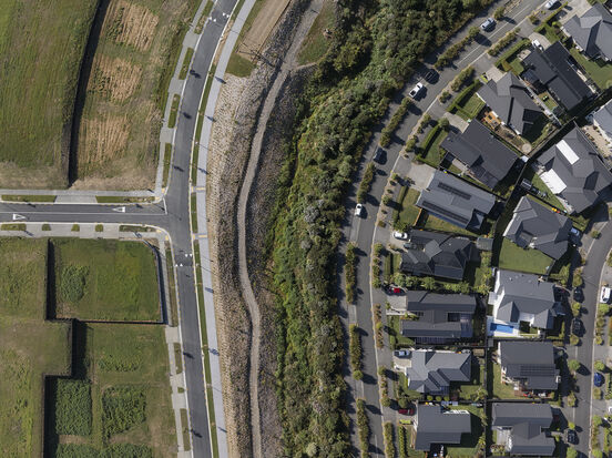
Paerātā Rise: A new suburb in the middle of nowhere.
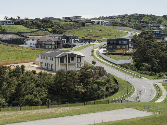
Flat Bush, Tuscany Heights.
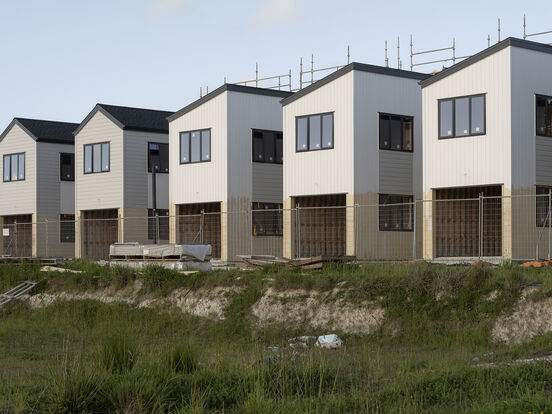
Westgate: For many of us used to older and more slowly accreted suburbs, new developments will have an unnervingly cookie-cutter feel.
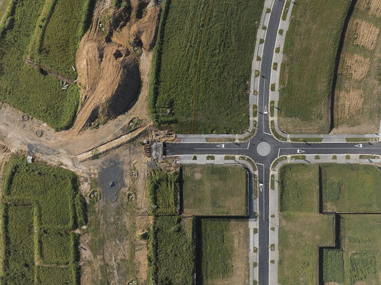
Paerātā Rise: Roads to nowhere.
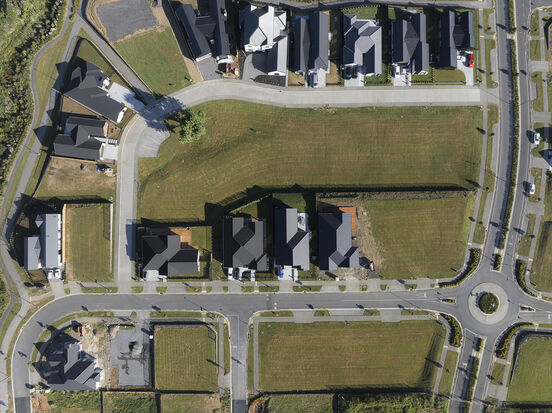
Paerātā Rise: 'Greenfield development is the modern frontier'.
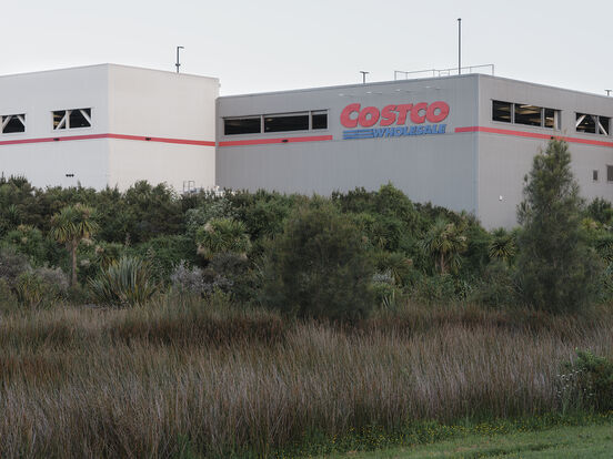
Westgate: The back end of Costco overlooking landscaping.
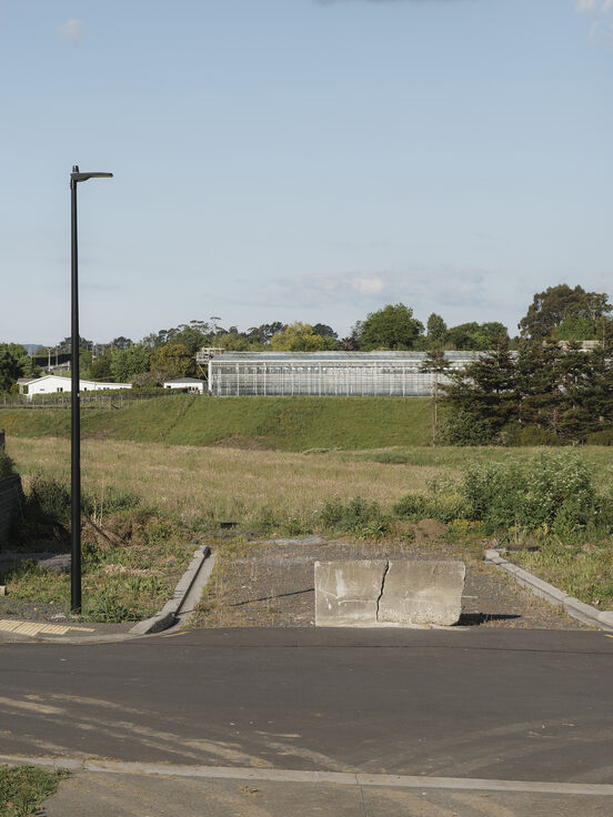
Paerātā Rise: New housing terminates in literal countryside.
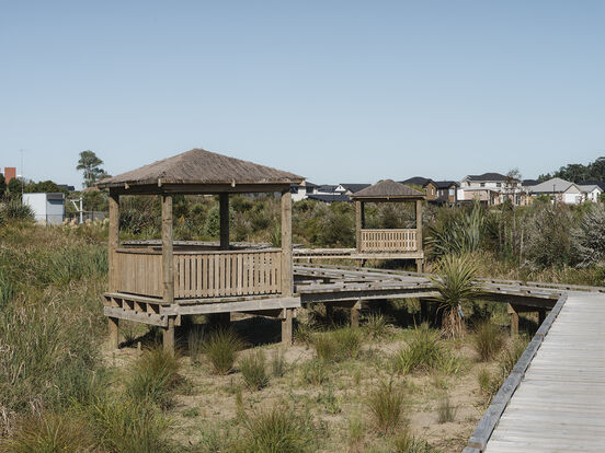
Hot desking in the suburbs.
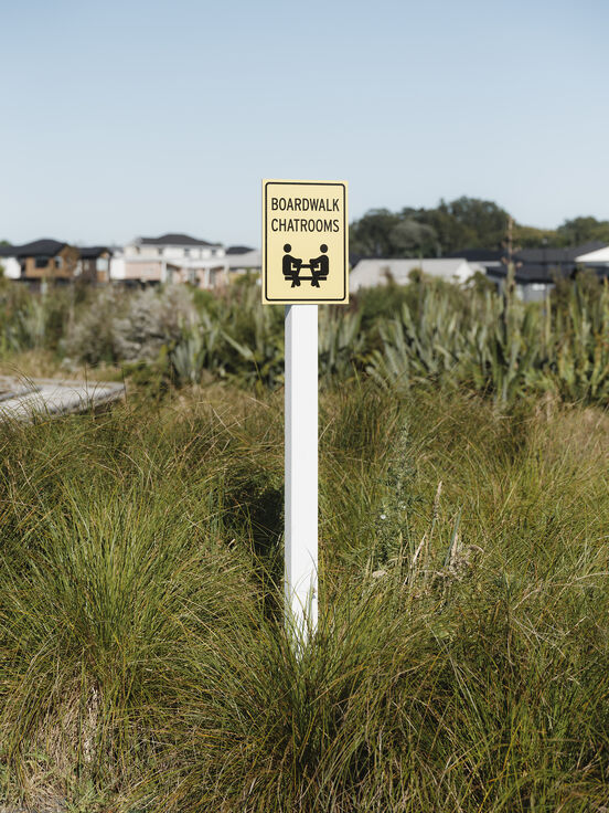
That's right, hot desking in the suburbs.